About
Current traffic data collection methods such as FCD (Floating Car Data) and video cameras are expensive and/or insufficient. Our project, Just a T.A.D, utilizes a UAV (Unmanned Aerial Vehicle) to capture aerial images/video of traffic flow on highways for image processing to calculate car density and spacing.
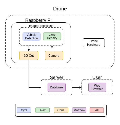
The Raspberry Pi along with the 3G USB dongle and camera is mounted onto the UAV, 3DR Iris+. The drone flies above highway traffic to capture images/videos for image processing on the Raspberry Pi. The image processing utilizes background subtraction, cropping, and vehicle detection in combination with more fine-turning techniques dilation, erosion, opening/closing, and contour detection to calculate car density and spacing. The processed data is then sent to the data server via 3G which is hosted on the cloud to remove as much load on the Raspberry Pi as possible for the intensive image processing. The web browser, which is also hosted on the cloud, queries the database to display its contents to the end user in an easy to access UI.