USGS Streamstats
The streamstats site can be found here:
http://water.usgs.gov/osw/streamstats/massachusetts.html
How to use:
Users just click on the Interactive Map link on the lower half of the page. They can then zoom in to the location of interest (in this case, Forge Pond). As long as the map is zoomed in past a resolution of 1:24,000 they can use the Watershed Delineation from a Point (black dot with + sign) to click on any point on a stream around the pond to get a drainage area mapped out. You can then click Compute Basin Characteristics to calculate the estimated drainage area. There's also great documentation on how to use StreamStats in more depth (http://water.usgs.gov/osw/streamstats/Version3UserInstructions-20150706.pdf).
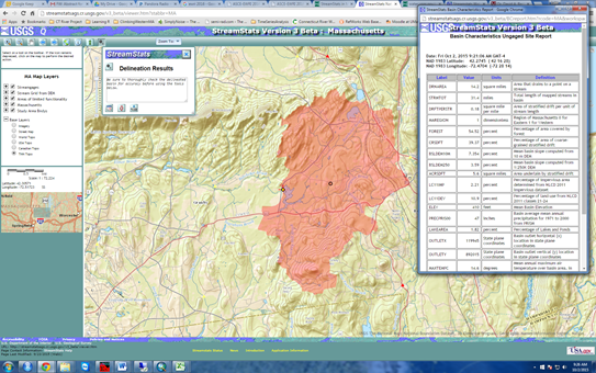
As an example, the screen capture below shows the FP drainage area as 14.2 square miles.
thanks to Luke Detwiler for the description and example graphics